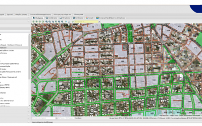
COMPLETION OF THE PROJECT « DEVELOPMENT OF SPATIAL DATA INFRASTRUCTURE FOR URBAN PLANNING FOR THE MUNICIPALITY OF ILION»
The Municipality of Ilion, is another Municipality that showed confidence in GET for the Development of the Geospatial Information Infrastructure of the Municipality, providing a modern electronic tool to the employees of the Municipality and the professionals, but...
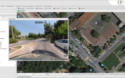
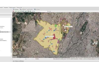
COMPLETION OF PROJECTS FOR THE MUNICIPALITIES OF PAPAGOU -CHOLARGOS AND HERAKLION FOR THE EXPANSION AND MODERNIZATION OF GEOINFORMATION MANAGEMENT TOOLS
GET successfully completed 2 projects for Local Government authorities, which aimed at the supply of "vertical" added value applications, exploiting and expanding the Spatial Data Infrastructures developed in previous projects. The projects were implemented for the...

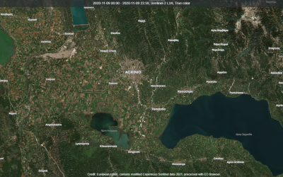
KATHIMERINI makes reference to the project “Environmental Observatory of the Municipality of Agrinio” implemented by GET
Kathimerini newspaper reported yesterday, August 21, on the very important project of the Environmental Observatory of the Municipality of Agrinio, which is implemented by GET. More specifically, in the article of Kathimerini, the Environmental Observatory of the...

Rineia: An important archeological site in the center of environmental monitoring for plastic pollution
Press Release The Athanasios C. Laskaridis Charitable Foundation and the Department of Marine Sciences of the University of the Aegean join forces to monitor the intertemporal plastic pollution in a place of the highest archaeological and environmental significance in...
GET for the Protection of the Environment
On the occasion of the World Environment Day, presentations were made of 2 innovative projects implemented by GET that contribute to the protection of the environment. The projects are implemented on behalf of the Region of Crete and the Municipality of Agrinio...
NEW PROJECT FOR THE DEVELOPMENT OF “OPEN ENVIRONMENTAL DATA PORTAL” FOR THE MUNICIPALITY OF PIRAUES
GET undertook the development of the "Open Environmental Data Portal" for the Municipality of Piraeus. The purpose of this service is to support the Mechanism for decision-making regarding actions, measures, future tools and the implementation of the Adaptation Plan...
NEW PROJECT “SUPPLY OF SPECIAL EQUIPMENT FOR CIVIL PROTECTION FOR OUTDOORS RISK MANAGEMENT FOR THE MUNICIPALITY OF HERAKLION”
GET and JGC SA jointly undertook the implementation of the new project for the Municipality of Heraklion, which concerns the supply of special civil protection equipment for risk management. In order to ensure more efficient measures and means of protection of the...
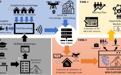
NEW R&D PROJECT UNDER THE EUROPEAN ΗΟΡΙΖΟΝ2020 UFO PROJECT
GET coordinates the new research project "5D ARCHitectural AIr Documentation - 5D ARCH AID" in the framework of the HORIZON2020 European project UFO. The project is implemented by a collaborative group of four (4) partners: Asociatia Monumentum, JGC, HERITAGE...
LIFE Awards 2021 LIFE Citizens’ Prize
The LIFE Awards recognise the most innovative, inspirational and effective LIFE projects in three categories: climate action, environment and nature protection. Among the 15 finalists chosen by the European Commission the Greek project ADAPT2CLIMA is included. The...
NEW PROJECT IN THE MUNICIPALITY OF CHANIA FOR THE MAINTENANCE AND EXPANSION OF THE SPATIAL DATA INFRASTRUCTURE FOR THE MUNICIPALITY
GET undertook the new project of the Municipality of Chania, which concerns the maintenance and expansion of the existing SDI of the Municipality. The Municipality of Chania, during the last decade, has systematically invested in the development of the necessary...
NEW PROJECT FOR THE MUNICIPALITY OF MAROUSSI FOR THE “EXPANSION OF GEOGRAPHICAL MANAGEMENT SYSTEM FOR URBAN PLANNING”
The Municipality of Maroussi and GET continue their successful longstanding cooperation with a new project. The new project’s scope is the sharing and the rationalized management of geospatial data, for the enhancement of the Services of the Municipality towards the...
RENEWAL OF GET’s COOPERATION WITH HCMR FOR THE RESEARCH PROGRAM EMODNET
GET renewed the cooperation with the Hellenic Center for Marine Research for the production of the software required for the Research Program EMODnet - Ingestion and Safe-Keeping of Marine Data 2. The objective of GET's work are included within Work Package 1 - WP1...

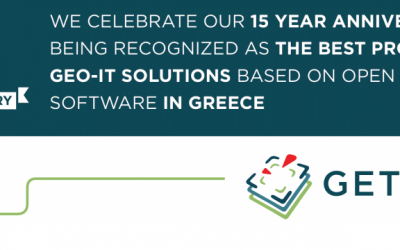
15 years of operation
In February '21 GET has completed 15 years of operation, implementing more than 430 projects in the field of Geoinformatics. Throughout this period, we have systematically served our mission which is "Making Location Matter". In each partnership, we seek to create a...
Integrated Innovative Intelligent System for the Support of Civil Protection Bodies
GET in cooperation with DOTSOFT (www.dotsoft.gr), under the framework of Interreg AIGIS, which is funded by the Cooperation Program Interreg VA "Greece - Cyprus 2014-2020, undertook and successfully completed the implementation of the project entitled" REPORT OF...
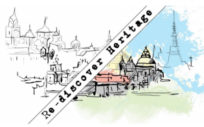
360 Degree Digital Imaging Services (sphere) in 4K resolution of the historic centers of the four historic cities of the IRC-HERMES project
The IRC-HERMES project is based on the previously successful HERMeS infrastructure (Europa Nostra Award, 2015) and includes the recording and digitization of buildings / settlements of high cultural interest, the automated prioritization of interventions to local...
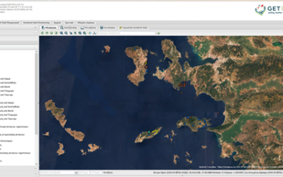
Environmental Observatory of the Municipality of Agrinio
GET undertook the implementation of the Environmental Observatory of the Municipality of Agrinio. The Environmental Observatory of the Municipality of Agrinio is part of the "Digital Strategy of the Municipality of Agrinio 2019-2024" and the main "Priorities of the...
New R&D Project under the 2nd round of the RESEARCH – CREATE – INNOVATE action
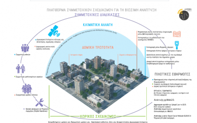
GET coordinates the new research project "eLEONAS ppWebGIS: PARTICIPATORY PLANNING PLATFORM FOR SUSTAINABLE DEVELOPMENT" in the framework of the Joint Action of State Aid for Research, Technological Development "Competitiveness, Entrepreneurship and Innovation...
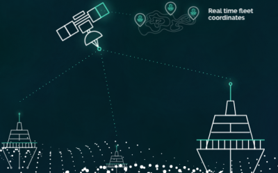
DeepSea
GET undertook the implementation of the automation of geospatial data management processes with free software technology - open source software for DeepSea https://deepsea.ai/company/ DeepSea is a pioneer in the development of artificial intelligence-based shipping...
GET in 2020
We at GET have a clear sense of purpose, to “Make Location Matter” by offering our clients a Common Operating – Geospatially based Picture (COGP). Our customers are able to innovate and provide, modern public geospatial enabled services that are interoperable by...
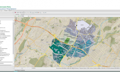
NEW PROJECTS IN THE MUNICIPALITIES OF KALAMATA AND NAXOS & SMALL CYCLADES FOR THE DEVELOPMENT OF SPATIAL DATA INFRASTRUCTURE FOR THE EACH MUNICIPALITY
GET successfully continues the development of projects in the field of Local Government, implementing Spatial Data Infrastructures (SDI), in accordance with the INSPIRE Directive. Two new Municipalities, the Municipality of Kalamata and the Municipality of Naxos and...