
GET to Develop Innovative Earth Observation Applications under Greece’s National Small Satellite Programme in Collaboration with Open Cosmos
Athens, 24 June 2026 – GET (Geospatial Enabling Technologies) and Open Cosmos Aegean have started working together on the development of data applications under Greece’s National Small Satellite Programme, a flagship initiative implemented by the Greek Ministry of...
GET Celebrates 20 Years of Leadership and Announces the Strategic Integration of EOFarm
Athens, February 2026 – GET (Geospatial Enabling Technologies – www.getmap.eu ), which marks 20 years of continuous and successful presence in the market on February 9, 2026, announces the completion of a strategic agreement for the integration of EOFarm into its...
20 YEARS OF INNOVATION IN GEOSPATIAL SOLUTIONS – STRONG PERFORMANCE IN 2025 AND PROMISING OUTLOOK FOR THE FUTURE
On February 6, 2026, the company celebrates 20 years of continuous and successful operation. This important milestone coincides with the completion of a highly productive year, 2025, confirming the company’s consistently upward trajectory and further strengthening its...
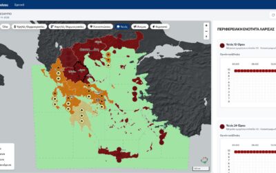
COMPLETION OF THE PROJECT “EXTENSION OF THE AUTOMATIC METEOROLOGICAL WARNING APPLICATION OF THE HELLENIC NATIONAL METEOROLOGICAL SERVICE
GET successfully completed the project “Extension of the Automatic Meteorological Warning Application” for the Hellenic National Meteorological Service (HNMS).The project concerned the improvement and further development of the existing application, originally...
GEOSPATIAL ENABLING TECHNOLOGIES ACTIVELY CONTRIBUTES TO THE MANAGEMENT OF ZAGORI AS A UNESCO WORLD HERITAGE SITE
GEOSPATIAL ENABLING TECHNOLOGIES (GET) successfully completed the project “Development Services of a Geospatial Information System to support the management of the Zagori area as a registered Cultural Landscape on the UNESCO World Heritage List.”To address the...
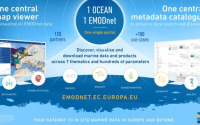
GET TO CONTINUE ITS CONTRIBUTION TO THE EMODNET DATA INGESTION PROJECT – ENHANCING ACCESS TO EUROPE’S MARINE DATA
GET is pleased to announce the continuation of its collaboration with the Hellenic Centre for Marine Research (HCMR) for the improvement and further development of the already operational platform “EMODnet Data Ingestion”. We continue to participate, as patner of...
THE REORGANIZATION AND CLASSIFICATION OF MAPS & FILES FOR THE DEPARTMENT OF TOPOGRAPHY OF THE MINISTRY OF RURAL DEVELOPMENT & FOOD IS IMPLEMENTED BY GET
GET has undertaken an important project with the Department of Topography of the Ministry of Rural Development and Food, for the provision of services for the classification and organization of maps and files. The goal is to modernize the management of geospatial data...

GET DEVELOPS A WEB-BASED CARTOGRAPHIC INTERFACE FOR THE PROVISION OF BUILDING REGULATIONS FOR DAEM AND THE MUNICIPALITY OF ATHENS
The long-standing collaboration of GET with the Municipality of Athens Computer Development Societe Anonyme (DAEM SA) continues with the undertaking of a new project, which involves providing services for the development of a web-based cartographic interface for the...
Announcement regarding the test use of the TRIMBLE MX7 Mobile Mapping data recording system that we are carrying out
GEOSPATIAL ENABLING TECHNOLOGIES LTD (hereinafter GET), (www.getmap.eu), announces that during the period from 19/02/2025 to 31/12/2025, we will carry out test work trials of the Mobile Mapping TRIMBLE MX7 data recording system. The test work trials will be done with...

NEW PROJECT FOR THE MUNICIPALITY OF DELTA FOR THE DEVELOPMENT OF GIS-SPATIAL DATA SERVICES OF THE MUNICIPALITY
GET successfully continues the development of projects in the field of Local Government, implementing Spatial Data Infrastructures (SDIs), in accordance with the INSPIRE Directive. A new Municipality, the Municipality of Delta, is another new customer, who showed...

DELIVERY OF THE DIGITAL TWIN OF THE CITY OF CHANIA MUNICIPALITY
The union of GET and ASTROLAVOS TECHNIKI successfully completed the creation of the new 3D Models of the road network and other infrastructures of the Municipality of Chania, as well as their integration in the municipality's existing Spatial Data Infrastructure...

GET IN 2024
Another successful year has ended, strengthening our market position as the leading provider of geoinformatics solutions based on open standards, free software and open data. In 2024, we successfully completed 39 projects in our areas of expertise. The geospatial...

NEW COOPERATION WITH THE REGION OF IONIAN ISLANDS AND RENEWAL OF THE COOPERATION WITH THE MUNICIPALITIES OF KALAMATA AND IGOUMENITSA FOR THE EXPANSION AND MAINTENANCE OF THE EXISTING SDIs
In the fields of Local and Regional Government, the integrated solutions provided by GET ensure long-term cooperation with our existing customers, through projects for the maintenance and expansion of their existing infrastructure. At the same time, the high quality...

COMPLETION OF THE CONTRACT WITH THE REGION OF CRETE FOR THE MAINTENANCE AND EXPANSION OF THE GEOSPATIAL DATA INFRASTRUCTURE OF THE REGION
GET has successfully completed the second contract for the expansion and maintenance of the Spatial Data Infrastructure of the Region of Crete. The Region of Crete is a representative example of good practice in modern geospatial information management, based on the...
GET HAS SUCCESSFULLY COMPLETED THE DEVELOPMENT OF THE WEB PLATFORM FOR THE CLIMATE CHANGE OBSERVATORY OF THE NATIONAL AND KAPODISTRIAN UNIVERSITY OF ATHENS
GET undertook and successfully completed the development of the Observatory's website on the topic "Climate Change and Health", for the National and Kapodistrian University of Athens. The Observatory "Climate Change and Health" of the National and Kapodistrian...

RENEWAL OF THE COOPERATION WITH THE MUNICIPALITIES OF ILION AND ORAIOKASTRO FOR THE EXPANSION AND MAINTENANCE OF EXISTING SDIs
The Municipalities of Ilion and Oraiokastro are two more Local Government bodies that choose GET’s solutions over time and invest systematically in the development and expansion of their Spatial Data Infrastructure (SDI). The SDI provides is considered to be the...

RENEWAL OF THE COOPERATION WITH THE MUNICIPALITY OF AGIOS NIKOLAOS FOR THE EXPANSION AND MAINTENANCE AND ENRICHMENT OF THE EXISTING SDI OF THE MUNICIPALITY
GET successfully continues the development of projects in the field of Local Government, concerning the implementation, maintenance and enrichment of Spatial Data Infrastructures (SDIs), in accordance with the INSPIRE Directive and the supply of "vertical"...

RENEWAL OF THE COOPERATION WITH THE MUNICIPALITY OF EGALEO FOR THE EXTENSION OF FUNCTIONALITY, MAINTENANCE AND ENRICHMENT OF THE EXISTING SDI OF THE MUNICIPALITY
GET successfully continues the development of projects in the field of Local Government, aiming at the implementation of Spatial Data Infrastructures (SDIs), in accordance with the INSPIRE Directive and the supply of "vertical"...
NEW PROJECT FOR THE MUNICIPALITY OF CHANIA REGARDING THE PREPARATION OF THE OPERATIONAL PLAN FOR SECURING THE COMMUNITY AND PUBLICLY BENEFICIAL SPACES OF THE MUNICIPALITY
The Municipality of Chania proceeded to signature of a new contract with GET, this time for the implementation of the project "Preparation of the Business Plan for securing the Community and Publicly Beneficial spaces of the Municipality of Chania”. The purpose of...

COMPLETION OF THE PROJECT FOR THE IMPROVEMENT AND FURTHER DEVELOPMENT OF THE “EMODnet Data Ingestion” platform for HCMR
GET has successfully completed another project for the Hellenic Center for Marine Research for the improvement and further development of the already operating "EMODnet Data Ingestion" platform. Specifically, the scope of the contract was the production of the...