International Conference on Theory and Practice of Electronic Governance (ICEGOV)
This year GET will participate in the International Conference on Theory and Practice of Electronic Governance (ICEGOV) which will take place in Athens, between 1 - 3 April 2020 [Conference Web Site]. The conference is coordinated by the United Nations...
Development of advanced GeoICT tools for the Municipal Enterprise of Water and Sewage of Thermaikos
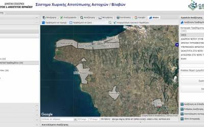
GET in cooperation with «NAMA Consulting Engineers and Planners S.A.» has successfully completed the development of innovative applications that support the operation and the decision making of the Municipal Enterprise of Water and Sewage of Thermaikos (DEYATH). The...
Spatial Data Infrastructure for the Greek islands
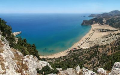
With more than 9,837 marine islands (islands, small rocky islands and deserted islands), the Greek islands account for 16% of the country's total land area, ranking Greece among the top island nations in the world. Greece has the highest percentage of island...
Advances in Change Detection and Continuous Land Monitoring Technology
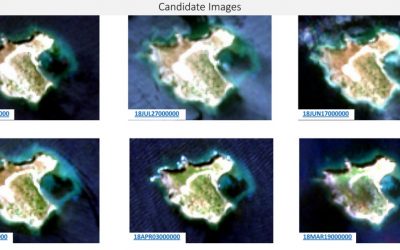
Introduction The monitoring of large regions of the world for significant changes has been a challenge in the past due to insufficient imagery and timeliness of the data. Thanks to accelerated development of satellite sensor technology and the increasing frequency of...
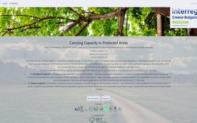
Development of a web tool for the calculation of the carrying capacity, the ecological footprint and the carbon footprint of a protected area
GET, in the context of the BIO2CARE project “Strengthening Protected Areas Management Capacity through an Innovative Sustainability Methodology” implemented under the Interreg Greece-Bulgaria 2014-2020 Program from the Department of Production and Management...
GET in 2019
GET (www.getmap.gr) achieved another year of strong financial performance in fiscal 2019, demonstrating the strength of our winning strategy of multiple engines of growth fueled by our diversified portfolio of services. One of the company’s greatest...
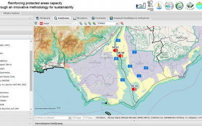
Development of Coordination and Decision-Making Software for Monitoring Nature Protected Areas in the context of the BIO2CARE Project
GET, in the context of the BIO2CARE project “Strengthening Protected Areas Management Capacity through an Innovative Sustainability Methodology” implemented under the Interreg Greece-Bulgaria 2014-2020 Program, undertook the implementation of a coordinating and...
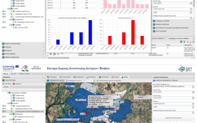
Development of advanced GeoICT tools for the Municipal Enterprise of Water and Sewage of Komotini
GET has successfully completed the development of innovative applications that support the operation and the decision making of the Municipal Enterprise of Water and Sewage of Komotini (DEYAK). The applications were developed as part of the WATER RESCUE project of the...
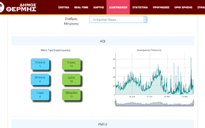
Development of a real time air quality monitoring platform for the Municipality of Thermi
GET has successfully completed the development of an innovative air pollution monitoring system using modern IoT sensors for the Municipality of Thermi. In collaboration with the Laboratory of Atmospheric Physics of the University of Patras, which undertook the...
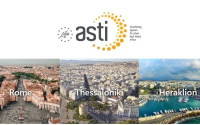
LIFE ASTI – Local conference and working table in Thessaloniki
A LIFE ASTI Project Information Day was held in Thessaloniki on Monday, October 7th. The event took place in the Municipal Council Hall of the Municipality of Thessaloniki. It was attended by officials of the municipal departments and other agencies, members of the...

GET supports “Copernicus Hackathon 2019”
GET is supporting the “Copernicus Hackathon 2019” for a second year in a row. The event will take place in Athens, in Corallia Si-Cluster premises. Every participant will have access to Sentinel Data through the Sentinel HUB API and create many unique-named instances,...
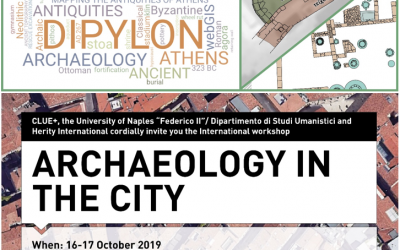
GET at workshop “Archaeology in the City”
GΕΤ participates in the workshop “Archaeology in the City”, which is organised by CLUE+ and the Naples University “Federico II” (Dipartimento di Studi Umanistici) in cooperation with Herity International, 16-17 October 2019. The workshop focuses on the urban expansion...
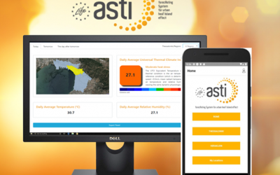
The LIFE ASTI system platform
The LIFE ASTI program aims to develop an operational forecasting system to monitor the Urban Heat Island (UHI) phenomenon in urban areas, but also to forecast extreme heatwave events that pose major risks for urban residents. All over the world, but also in Europe,...
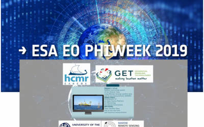
GET at Φ-week event organised by ESA
GΕΤ participates in the Φ-week event, which is organised by ESA 9-13 September 2019, focusing on the latest developments and trends in EO Open Science and FutureEO. GET will present an Ε-poster about the “Development of Local EO Algorithms for Monitoring the Greek...

GET participates at the Living Planet Symposium 2019 of ESA
The Living Planet Symposium (LPS2019) of ESA took place on the 13-17 of May 2019 in Milan, Italy. GET in cooperation with the Environmental Radioactivity Laboratory of NCSR“D” and Ph.D. candidate Georgia Mavrokefalou, under the Industrial Scholarship Program of...
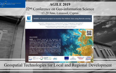
The MARRE research project at the 22nd AGILE 2019 conference
The MARRE research project was presented at the annual AGILE 2019 conference (Association of Geographic Information Laboratories in Europe), which was held in Limassol, Cyprus on 17-20 June, 2019. The theme of the conference was Geospatial Technologies for Local and...
Interreg V-A “Greece – Cyprus 2014-2020” Programme
Geospatial Enabling Technologies (www.getmap.eu) in cooperation with DOTSOFT SA (www.dotsoft.gr) in the framework of the AIGIS - https://aegisproject.eu/aigis/ project, financed by the Interreg VA “Greece - Cyprus 2014-2020 Programme”, signed the starting contract...
Deliverables of month 9 for the research project MARRE (T1EΔΚ – 02966)
Deliverables of month 9 for the project MARine monitoring system of the Hellenic Seas using REmote sensing satellite data and in-situ measurements (MARRE – Project title: Τ1ΕΔΚ-02966) under the framework “RESEARCH – CREATE – INNOVATE” of the Operational Programme...
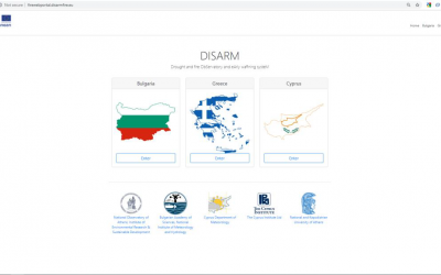
Development of a web site and of a Fire Web Portal for the National Observatory of Athens under the DISARM project
GET in the framework of the «DISARM - DROUGHT AND FΙRE OBSERVATORY AND EARLY WARNING SYSTEΜ» project of the transnational cooperation programme Interreg Balkan-Mediterranean 2014-2020 in which National Observatory of Athens participates, undertook the development of...
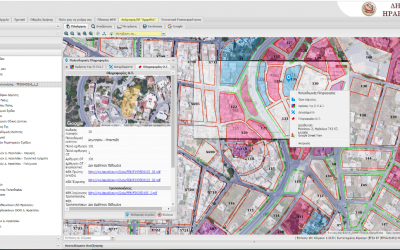
New projects in the Municipalities of Chania, Heraklio and Keratsini that aim to the enrichment of the current Urban Planning applications
GET has continuously developed Local Government projects, aiming at the implementation of various Spatial Information Infrastructures – SDIs, based on the INSPIRE framework and the development of Urban Planning applications. The municipalities of Chania, Heraklio and...