ppCity project has already begun!
GET participates in the implementation of the research project with the title “Integrated System for the Spatial Decision Support and Participation”, acronym ppCity, project code: Τ1ΕDΚ-02901 and MIS code 5029727 under the framework of the Action “RESEARCH – CREATE –...

Farnacon and GET, with the innovative FarmaSense at the international competition Copernicus Masters.
With the innovative platform FarmaSense,which will support daily activities for farmers, Farmacon and GET participate at the international competition Copernicus Masters, for one of the awards of innovative solutions and ideas with remote sensing data, in agricultural...
Simularity and Geospatial Enabling Technologies (GET) Sign Partnership MOU
Exploiting a huge volume of free available Copernicus System Sentinel-2 satellite data, being collected daily, can be easily and effectively only with the use of artificial intelligence. This is what our partnership with Simulirity provides to us, through Simularity's...
Leaflet for SLIPO: Scalable Linking & Integration of Big POI Data
SLIPO: Scalable Linking & Integration of Big POI Data, receiving funding from the European Union’s Horizon 2020 research and innovation programme under grant agreement No 731581, is in implementation phase. You can see here the relative leaflet.
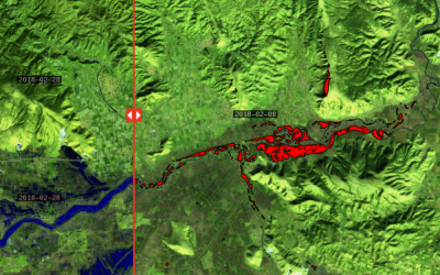
Article regarding use of satellite imagery in crisis management after floods: GET’s solution
The web portal Prevention web publishes article regarding the use of satellite imagery for crisis management after floods with detailed reference to the solution provided by GET in the case of floods in Farkadona at region of Thessaly last February. The article has...

GET at the Workshop on Copernicus uptake by public authorities
GET presented "Copernicus Data Driven Services for Regional & Local Government in Greece" during the workshop on Copernicus uptake by public authorities that was organized by EC-DG Grow at Brussels on 23rd of April 2018. You can see the presentation here.
Portal for access in Copernicus Satellite Data through OGC services for the Region of Central Greece
NAMA S.A. in cooperation with GEOSPATIAL ENABLING TECHNOLOGIES will create a Portal for Open Satellite Data (Copernicus system) access in almost real time for the Region of Central Greece. Via dynamic view and download services according to OGC standards, the user...
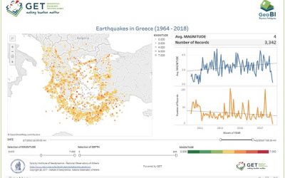
Dashboard for Earthquakes activity in Greece
Have you ever wondered about earthquake activity in Greece within the last 54 years ? Check out this new interactive dashboard from GET based on open data (Access Earthquake Catalogues from Institute of Geodynamics, National Observatory of Athens).
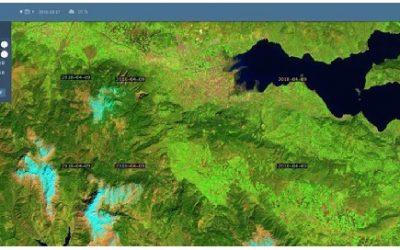
Use of satellite data for crisis management during and after flood
In the last couple of years we have experienced record-breaking extreme weather. In terms of lives lost and property damaged, floods are among the most devastating natural disasters. To assess the damages experts use different approaches, among which the use of...

GET cooperates with Dipylon
It is a big pleasure and honor for GET to announce its cooperation with Dipylon, the non profit organisation for the study of the ancient topography and the cultural environment through interdisciplinary research on Archaeology, History, Informatics and Cartography....

Spatial data management services with the use of GIS for the Municipality of Zitsa
GET started to provide services for the Municipality of Zitsa in order to organize Municipality's spatial data with the use of GIS. As part of the project, GET will develop Geo-Informatics applications based on free and open source software as well as web services for...
EARSC and CRCSI sign MoU
Brussels, 7th March 2018: The European Association of Remote Sensing Companies (EARSC) and the Cooperative Research Centre for Spatial Information (CRCSI) through Spatial Information Systems Research Ltd (SISR), signed a Memorandum of Understanding (MoU)....
GET – Farmacon cooperation
GET develops for Farmacon SME (www.farmacon.gr) an operational solution which will support sustainable agriculture and good agricultural practices with the use of cutting-edge technology and innovative tools for information analysis and visualization. This consulting...
After a year of successful cooperation, GET and Sinergise decide to expand their partnership in Australia and GET becomes reseller of Sinergise for Australia area too.
In January 2017 Sinergise agreed to a reseller partnership with GEOSPATIAL ENABLING TECHNOLOGIES (GET). As part of this alliance, GET, GeoInformatics solutions provider based on open standards, open and free software and open data, continues to develop Sinergise’s...
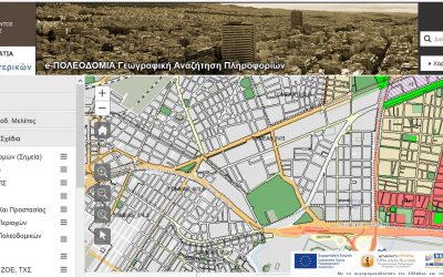
GET in Electronic Urban Planning Project
GET, as subcontractor of INTRASOFT INTERNATIONAL S.A. and TERRA MAPPING THE GLOBE, undertook and completed for the project "ELECTRONIC URBAN PLANNING: GEOGRAPHIC INFORMATION SYSTEMS FOR PREFECTURAL AUTHORITIES OF THE COUNTRY" the development of application for the...

GET participates at the 6th International Conference on Remote Sensing and Geoinformation of Environment
The 6th International Conference on Remote Sensing and GeoInformation of Environment will take place on 26-29 of March 2018 in Paphos, Cyprus. GET' team in cooperation with team from the Geography Department of Harokopio University will present the paper...
GET participates at the 1st Remote Sensing in Geo-Sciences Day
Remote sensing and Space Applications Committee of Greek Geology Company organizes the 1st Remote Sensing in Geo-Sciences Day which will take place on the 21st of February 2018 09.00-16.00 in CeremonyChamber the Charokopeion University. This Day will be a very...

GET supports AETHER initiative
GET, in the framework of corporate social responsibility, is pleased to announce that we are actively supportings the AETHER initiative on the monitoring of particulate matter air pollution in the city of Patras. Suspended particles are one of the key factors...
Spatial Data Infrastructure for the Municipality of Agia Paraskevi
GET begins cooperation with the Municipality of Agia Paraskevi for the development of a Spatial Data Infrastructure. The objectives of the project are: development of Spatial Data Infrastructure for the Municipality of Agia Paraskevi through customized data design,...
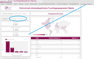
Published number of visits for the Regulatory Authority of Energy GeoPortal
The very important project of the Regulatory Authority of Energy is reflected in recent published features regarding number of visits in the web page of the relative application (www.rae.gr/geo/). We believe that these data are a very reliable way which presents the...