PULCHRA City Challenges Platform
The National and Kapodistrian University of Athens in collaboration with GET successfully completed the implementation of the electronic PULCHRA City Challenges Platform. The implementation took place in the framework of the Science in the City: Building Participatory...
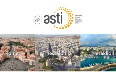
Invitation for the 2nd European Workshop of the LIFE ASTI project
GET, as a partner of the project "LIFE ASTI - Implementation of a forecAsting System for urban heaT Island effect for the development of urban adaptation strategies", invites you to attend the 2nd European Workshop of the project, on "Urban Heat...
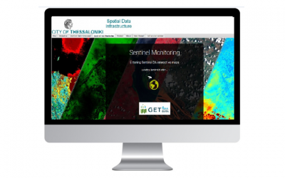
RENEWAL OF THE CONTRACT WITH THE MUNICIPALITY OF THESSALONIKI FOR ACCESS TO COPERNICUS SATELLITE DATA, VIA STANDARDIZED WEB SERVICES
The Municipality of Thessaloniki renewed the contract for access to the Copernicus Satellite data, via standardized web services. The project provides almost real-time access to Copernicus system Sentinel-2 & 3 (OLCI) satellite data via standard OGC (OGC Web...
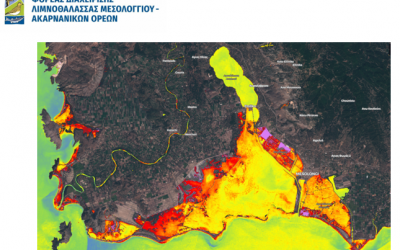
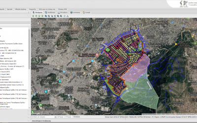
“INTEGRATED GEOSPATIAL DATA SYSTEM” FOR THE MANAGEMENT AGENCY OF MESOLOGIO LAGOON – AKARNANIC MOUNTAINS
The Management Agency of the Mesologi Lagoon - Akarnanian Mountains is a Legal Entity under Private Law. The purpose of the Management Agency is the administration and management of the Mesologi - Aetoliko Lagoon National Park, estuaries and downstream of the rivers...
New project in the Municipality of Chalandri for the expansion and modernization of geoinformation management tools
The Municipality of Chalandri, being a long-term customer of GET, has acquired an integrated geoinformation infrastructure based on open source technology. The infrastructure hosts a large number of geospatial data and serves the functions of the Municipality at the...

NEW PROJECT IN THE MUNICIPALITY OF ILION FOR “THE DEVELOPMENT OF INFRASTRUCTURE OF URBAN PLANNING GEOSPATIAL INFORMATION FOR ILION MUNICIPALITY”
GET successfully continues the development of projects in the field of Local Government, implementing Spatial Data Infrastructures (SDI), in accordance with the INSPIRE Directive, for the supply of "vertical" Urban Planning applications. The Municipality of Ilion, is...
APPLICATION SPATIAL CONTROL SYSTEM RAE
The Energy Regulatory Authority (RAE) in collaboration with Geospatial Enabling Technologies (GET) have developed a System of Spatial Control of Applications (SCA) for the issuance of electricity generation licenses from Renewable Energy Sources (RES) and Electricity...
New R&D Project under the 2nd round of the RESEARCH – CREATE – INNOVATE action
GET participates in the implementation of a new research project under the framework “RESEARCH – CREATE – INNOVATE” of the Operational Programme “Competitiveness Entrepreneurship Innovation” (EPAnEK 2014-2020), Partnership Agreement 2014-2020. The new project, which...
New projects for the Municipalities of Papagou -Cholargos, Heraklion and Agia Paraskevi for the expansion and modernization of geoinformation management tools
GET continues successfully the development of projects for Local Government authorities, aiming at the supply of "vertical" added value applications, exploiting and expanding the Spatial Data Infrastructures developed in previous projects. Municipalities of Heraklion...
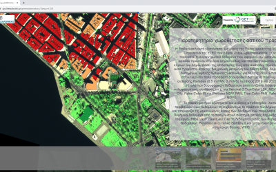
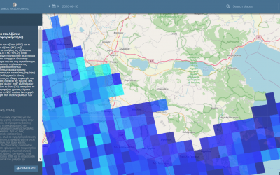
Observatory of Urban Green Siting for the Municipality of Thessaloniki
In order to utilize data and information, which are provided to the Municipality of Thessaloniki via the COPERNICUS satellite imagery service, GET developed the “Observatory of Urban Green Siting” for the Municipality (https://sdi.thessaloniki.gr/greenobservatory...
Creation of Geospatial Information Infrastructure in Oinousses
Creation of Geospatial Information Infrastructure in Oinousses Under the Corporate Social Responsibility framework of actions https://lnkd.in/ecGu9U5, which are systematically undertaken by our company, we decided to start a three-year program during which we will...
Sentinel 5 atmospheric monitoring data available in the SDI of the Municipality of Thessaloniki
Copernicus (http://www.copernicus.eu) is the world's largest open source data sharing program. Its goal is to provide continuous, reliable and free satellite Earth Observation (EO) data, with global coverage. Recognizing its metropolitan role, the Municipality of...
Design and development of collection, management and dissemination of historic buildings information software in settlements located in the North Aegean Region
The objective of the Project, the implementation of which has been undertaken by GET, is the provision of services for the "Design and development of software for collecting, management and promotion of historic buildings information in settlements of the North Aegean...
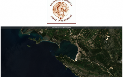
Development of Spatial Data Infrastructure for the Municipality of Igoumenitsa
The scope of the Project, the implementation of which has been undertaken by GET, is the modernization of the management of geospatial information, in order to support planning and decision making. The project initially focuses on the organization of the existing...
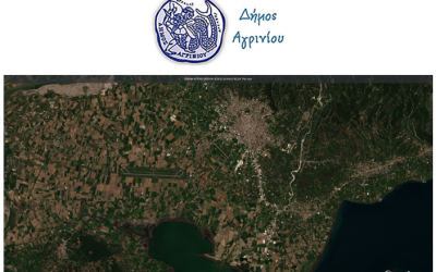
Expansion and upgrade of the Geographic Information System of Agrinio Municipality
GET undertook the implementation of the "Expansion and Upgrade of GIS of Agrinio Municipality". The project is part of the actions of Development and implementation of "smart city” solutions in the Urban areas, of Sustainable Urban Development in the region of...

Design & Development of the IRC Web Application Information System, in the framework of the “integrated platform for the strategic management of buildings / settlements and the collection, support, protection and promotion of Cultural Heritage”
RC "Athena" participates in the design and development of the IRC-HERMES project (http://irc-hermes.eu/), with the aim of providing a single platform for the strategic management of buildings / settlements and the collection, support, protection and promotion of...
New R&D projects under the 2nd round of the RESEARCH – CREATE – INNOVATE action
GET participates at the implementation of new research projects under the framework “RESEARCH – CREATE – INNOVATE” of the Operational Programme “Competitiveness Entrepreneurship Innovation” (EPAnEK 2014-2020), Partnership Agreement 2014-2020. The projects, which are...
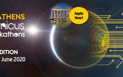
GET continues to support Copernicus Hackathon!
Due to the pandemic, for the first time the competition will be held exclusively online and the time available for the development of solutions by the participants will be extended to 4 weeks. The Copernicus Hackathon Online Edition 2020 starts on May 8 and lasts...
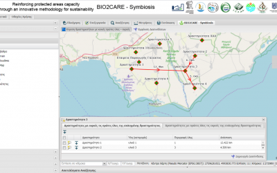
Development of a web tool for the estimation of industrial symbiotic activities
GET, in the context of the BIO2CARE project “Strengthening Protected Areas Management Capacity through an Innovative Sustainability Methodology” implemented under the Interreg Greece-Bulgaria 2014-2020 Program from the Department of Production and Management...

Opertus Mundi online surveys on geospatial data use
Data owners, producers, and consumers needed to shape Europe’s geospatial data marketplace. In the H2020 project Opertus Mundi, we’re in the process of setting up a geospatial data marketplace for Europe. Our vision? A single point of entry for easily searching for,...